By Peter Cormack
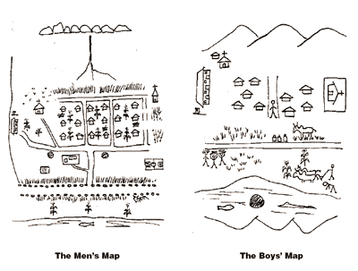
A team of visitors spent time with villagers in Sa-atusa, Ethiopia, gaining understanding of the situation in the area and the results of some improvements to irrigation work. After spending some time walking around the area, they asked a group of people to draw a map of their area. Soon a few men were busy and a crowd of about 60 people had gathered. Some of these gave suggestions to the ‘artists’ who might respond with discussion or argument. Gradually the group moved towards a general agreement.
Several children took a keen interest too. But some of the men chased them away, saying ‘This is men’s business!’ After this had happened a couple of times, we called the boys and encouraged them to begin drawing their own map. Though a little hesitant, three or four boys agreed to begin. This small group was also soon busily drawing, while a much larger group of boys watched and gave suggestions.
The men...
The men’s map grew and grew! They added rivers, mountains, two churches and a skull to indicate livestock losses. Eventually the map covered a large area - about 15 by 10 metres. When they were finished we asked them to explain it to us. The map became a powerful means for them to get over a ‘big picture’ of their area, showing the power of a joint community effort.
The people realised that their agreement and working together had produced something memorable, useful and beneficial to them all. And this lesson seemed likely to stay with them. When the map explanation was finished, the crowd clapped enthusiastically.
The boys...
When the boys completed their map, it contained several items not included on the men’s map. The boys described these to the crowd - the lake included a fish, crocodile and hippopotamus and a rocky island. In their sketch of the grazing area they added an ox. In the crop area they included a man ploughing with oxen. They drew women collecting and carrying firewood. Next to the road they drew three bags of charcoal.
Based on our observations, we believe the boys’ map probably represented the area more accurately than the men’s. For example, only one living creature appeared on the men’s map (a fish) and not one single human. Yet the boys’ map included six humans as well as several other creatures. It seemed that the men tended to look only at the economic/material side of things.
As the boys finished their explanation, again the crowd clapped enthusiastically. These boys who had earlier been chased away, now had their moment of appreciation!
...and the women
While the men and boys were busy drawing their maps the women were involved in a fascinating exercise looking at their time-use for the different activities which they are involved with on a daily basis. Women ran to their homes to bring items to symbolise different activities. All the women, no matter what their age, were keen to share their thoughts - to correct what another was saying or to give support when a point needed emphasising. After a while some men came over to watch - fascinating! When some men tried to comment or correct the women, the women told them to stop interfering and leave the group alone - a very significant step in a culture where women are rarely assertive. The women used pebbles to indicate the relative amounts of time.
These exercises had encouraged the people to work together in looking at their community and their roles - hopefully the exercises could be adapted in the future when planning for community development. In conclusion all we can say is, ‘Hand over the stick!’ Let the people find their own solutions...
Peter Cormack works with World Vision Australia. This article is adapted from one which appeared in Together June 1993 and is used by kind permission of World Vision.