by Dr Thomas Kroeck.
Participatory Learning and Action (PLA) methods can be very helpful as a way of collecting information for planning and setting up development projects. They have a number of advantages over formal surveys.
Some of these advantages are…
- Local people are encouraged to participate from the beginning when projects are planned.
- The costs of using PLA methods are usually much lower than for formal surveys.
- The information is immediately available to everyone, both in the community and those planning the project.
Because of this, PLA methods are very suitable for development organisations with a bottom-up approach and limited financial and personnel resources, such as churches and other NGOs.
In the Diocese of Mount Kilimanjaro this development approach is still new. Some PLA methods have been used in seminars but we are still learning how to use PLA for the planning and implementation of sustainable development projects.
In October 1992 we used PLA methods in Kiru Dick village in Babati District for the following reasons:
- to help village people understand their situation and to take action for their own development
- to help part-time church workers (evangelists) from the Babati area to play an active role in the development of their villages
- to get a deeper understanding of the situation in the rural areas in order to plan relevant development projects and training programmes.
Background to the area
Kiru Dick village is in Babati District in northern Tanzania. It is 12km north-west of Babati town, on the southern slopes of Kiru Valley which is part of the Rift Valley. Kiru Dick consists of four hamlets with a total population of about 1,700. For the PLA the hamlet Mbuni was chosen. It has an area of about 20km2 and a population of about 640. At least one third of the area is cultivated by leasehold farms.
The PLA team
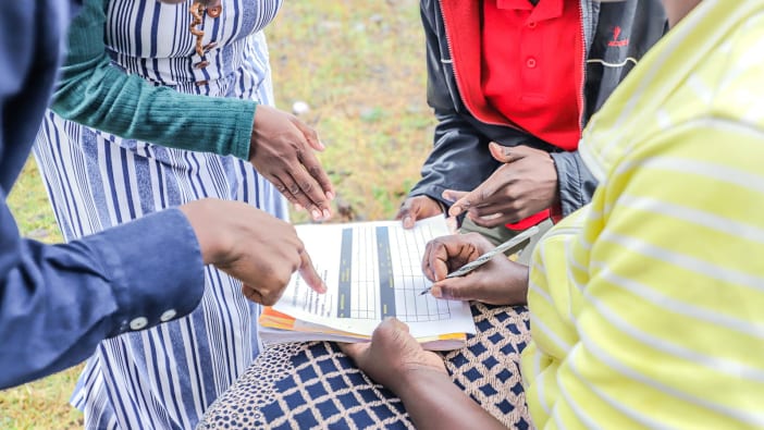
We used a team of 20 persons – some from the village and some from outside. The core team were responsible for the organisation. They included the diocesan development officer, two agriculturalists from a diocesan training centre, a Mothers’ Union worker and local people appointed by the village government and the church, and church workers from the Babati area, who had received three months’ training at the training centre. Thirteen team members were from the village and seven were outsiders. There were five women and fifteen men. The majority of team members had primary education and all were literate.
A first visit was made one month before the seminar and the proposed PLA exercises discussed with village leaders and church elders. However, no definite programme was agreed at that time. When they arrived the team found that the village government had already announced their programme. As a result the programme prepared by the team was adjusted to some extent. Other changes were made during the course of the seminar. The following programme is the result of this process.
Programme
Day One On arrival, the team members met first with the village chairman and secretary and later with the village elders and discussed the history of the village, agriculture, livestock and health problems.
Day Two The team met to introduce the new members, explain the principles of PLA and learn about the use of mapping and seasonal charts. In the afternoon they began the exercises with the villagers. They began by mapping the Mbuni hamlet with them, moving on to developing a seasonal chart. (See pages 8–9.)
Day Three The team discussed gathering of information through informal interviews and group discussions. In the afternoon they divided and met with three groups – women, youth and community leaders (with whom they did ranking exercises). In the evening they were given an introduction to transect walks.
Day Four The following day they again divided into three groups – two taking different transect walks and the third group visiting the dispensary to gather information about the health situation. During the week the team met regularly to discuss and evaluate their activities – usually early in the morning and each evening.
Day Five On the last morning they met to discuss their findings and how to present them to the villagers. During the final afternoon they presented the findings to the villagers and discussed what planning and activities should result.
Conclusions
As none of the team members, including the core team, had much experience in conducting PLA, this exercise was a good learning opportunity. Although there were some problems, the overall impression was that all team members enjoyed the seminar and learnt a lot. Some of the problems we encountered were:
- misunderstandings about the programme due to our lack of detailed planning with the village people
- poor attendance and participation in the group discussions
- attitude of distinction between scientists and villagers
- poor time keeping
- difficulty in drawing a village map on a flip chart during the meeting (later the local team members drew a map on the ground).
On the other hand there were some very positive experiences, such as:
- good co-operation between insiders and outsiders in the team
- much information could be gathered during the social ranking.
Follow-up and results
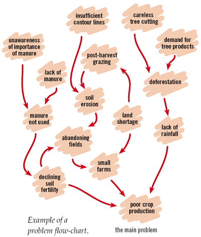
One of the problems identified during the PLA was soil erosion. As a result of the information collected and the awareness of the problems, seminars and practical training on soil conservation were started. This work is still continuing and gaining more momentum as the positive results of contour strips become visible.
For future exercises some suggestions were made:
- to show slides or a film in the evening to attract more people to the seminar
- taking a football to the village for recreation with the village youth
- drawing a village map on the ground instead of on paper.
Dr Thomas Kroeck works with the Diocese of Mount Kilimanjaro. His address is: PO Box 1057 Arusha Tanzania.
Email: [email protected]